Tuesday, March 27, 2018

What is an As-Built Survey?

Have you ever wondered how customers verify major construction projects? When a builder hands over the keys to a new school building, for instance, how do the school officials know that the public got its money's worth? Is the school building the right dimensions and in the exact location that the contract specified?
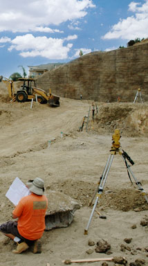
An as-built survey performed by a surveying company can answer most of these questions. As-built surveys seek to verify that what the builder's contract specified was what they delivered to the customer as a final product. Many land surveyors in Los Angeles offer this type of survey for major construction projects throughout Southern California.

As-built surveys can also help determine if the project in question affects the environments and local ecosystems in ways that environmental regulatory agencies have already approved. As-built topographical surveys can show how the project impacts water flow and erosion which can have major effects on local ecosystems.It could be a costly mishap to exceed environmental impact limits. It can be essential to discover any problems early on because the customer will usually have an easier time holding the construction company responsible if they can quickly demonstrate any errors. Land surveyors in Los Angeles could arm customers with vital information if construction did not meet the contractual specifications.

Another possible benefit of an as-built survey is the ability to verify that the construction company located the structure or project precisely at the specified location. Missing the proper position by just a relatively small amount can be a major problem for the customer. An as-built survey can ensure that the project managers observed the appropriate setbacks and property line restrictions. This type of review can also prove that all dimensions of the finished project are correct. Land surveyors in Los Angeles perform many types of surveying duties, but as-built surveys could be considered one of the most important for significant construction projects.

Tuesday, June 21, 2016

Why Is Topography Important to Your Land Development Project?


Suburban and urban developments have been growing throughout California, and it is commonly a very lucrative field. However, when completing a land development project, you want to make sure you have a comprehensive understanding of the area and all of its eccentricities. Thousand Oaks land surveyors are essential to gaining a detailed understanding of the land that you hope to build on and can provide you with extensive topographical maps to help you build appropriately.

What is topography? The earth is three dimensional and subtle changes and alterations in land can greatly affect the soundness of structures on its surface. It can additionally significantly affect the efficiency of land development designs. Therefore, topography identifies the roughness, configuration, shape, relief and other three-dimensional attributes on the earth’s surface. Thousand Oaks land surveyors use specialized tools to look at these qualities and create an extensive map.

After observing the land and assessing the information, they can provide you with an extensive and specific picture of the area you hope to develop. These maps show both natural and man made features including hills, lakes, streams, highways and existing structures. This information can then be used to accurately design building projects. With these tools, you can determine the best location and layout for pipelines, dams, fire control routes, trails, roads and buildings. This can help you also assess the best use for the land, and you can decide where to put commercial, industrial and residential space.

While the government has compiled a number of general topographical maps of common regions, there are many holes in this information. However, by working with Thousand Oaks land surveyors, you are able to receive detailed analysis of the mapped information, and they can ensure that you receive the detailed information that you need. Chris Nelson Associates has the knowledge and experience to help you efficiently and successfully design your next land development project.

For more details regarding Thousand Oaks land surveyors, please go to www.chrisnelsonassociates.com.

Thursday, October 22, 2015

How Modern Technology Improves Topographic Maps


Topographic surveys, sometimes called "topo surveys" for short, show not just the contours but the
terrain, elevation, and natural and man-made features of a parcel of land. They have been used for
centuries by engineers, architects and other designers to decide what kind of construction is best fitted to the land, and what changes may need to be made to build on it. While historically surveyors used various optical leveling instruments to make a topographic map, the modern Los Angeles topographic survey employs more high-tech solutions.

An aerial topo survey is one of the most useful innovations. These surveys are performed by taking
photographs in an airplane or helicopter at a specific distance from the ground. Multiple photographs
are taken from different points over the land. Then the elevation is calculated by comparing pairs of
photographs to create a kind of 3-D perspective, the same way our depth perception works by seeing
the world through two eyes.

However, aerial surveys are limited in how accurate they can get, so sometimes a Los Angeles
topographic survey must be performed on the ground. The surveyor walks over the entire land, taking measurements at specific intervals depending on how precise the survey needs to be. Modern surveyors use survey-grade GPS equipment. While the commercial GPS in your car or cellphone may be accurate down to a few feet, a survey-grade GPS, when carefully calibrated, can be accurate down to a few centimeters, or even millimeters if it's kept stationary for a period of time. Survey-grade GPS units also calculate vertical as well as horizontal location, measuring the exact height of a particular point.

Having a good topographic map is essential in starting any major construction project. Whatever purpose it's going to be used for, modern technology can ensure that a Los Angeles topographic survey is accurate down to as precise a degree as a designer needs.

Tuesday, February 17, 2015

Qualities to Look for in a Land Surveyor

Building something can be an exciting process, even if it is just an addition on your lovely Southern Californian home. Before you can start building you will have to hire the services of a land surveyor. If you are like many people, you will probably have no idea where to start. There are a few simple things to look for when searching for a Los Angeles land surveyor.

A competent surveying company will be able to provide references and referrals from past clients. This is a sure sign that you have found skilled professionals. Their references can tell you how timely and thorough they were. Since breaking ground could be on hold until surveys go through, it is important that the company you choose can work efficiently.

Another quality you should seek in your surveyors is up to date equipment. A company that keeps up with technology can give you the most accurate readings of your land. It also indicates dedication to the industry if a company invests in top quality equipment. You should also make sure that the company you hire has all kinds of insurance, including liability and workman’s compensation. Having insurance will protect you, the consumer, from any accidents or unforeseen circumstances.

Finally, the company should be local to your area. Hiring a Los Angeles land surveyor is important because they will know the local laws and regulations. They will have dealt with the local government and, therefore, will be of help to you and your project.

 Do not be daunted by the idea of hiring a land surveyor. If you can find a company that has all the above qualities, you can trust that they are professionals who know what they are doing and can help you. Southern California is a beautiful place to live and raise a family. Expanding your home could be a more affordable and easier option than moving into a large house. If this is the case, finding a Los Angeles land surveyor you can trust will help you get the job done.

Tuesday, July 22, 2014

The Importance of Surveying in Land Development Projects


Building and development is one of the hallmarks of civilization. While there are cultures that do not build many permanent structures, most of the world regards architecture and land development as central to progress. In order to build anything, from a park to a skyscraper, one of the first steps is to survey the land in question. A land development survey can take many different forms, but each is designed to help make the most of a piece of property.

Different Types of Survey

Most of the earliest surveys were topographical in nature, since the landscape and geography of the world was still being explored. Today there are still topographic surveys, but many others types as well. Some of the various kinds of survey include: flood elevation, construction, boundary, as-built, and ALTA/ACSM surveys. Determining where a piece of land falls within the local flood plane is very important for builders and for insurance purposes. A flood certificate is required by most investors to ensure a property is prepared for the possibility of flooding. Boundary surveys are most often used when the corners of a parcel of land must be re-established before a construction or building project can go forward. Each land development survey, like those listed above, has minimum standards that determine its usability. If a survey is not completed to the required specifications, the result could be disastrous for the final development project.

Trust the Survey Experts


Since performing accurate surveys is essential to the future integrity of building projects, it makes sense to trust the experts in survey taking, such as Chris Nelson & Associates. They are well-versed in each type of land development survey that your project may require. If you find that you want to create something out of an empty piece of property or would like to transform and old development into something different, contact Chris Nelson & Associates. They will complete your surveys professionally, accurately, and quickly allowing your land to be developed accordingly. 

Thursday, June 26, 2014

Breaking Down the 3 Step Process of ALTA Land Surveys


Lenders, corporations, and title companies often require ALTA Surveys when dealing with commercial properties, especially those of value. ALTA stands for the American Land Title Association, which is a trade association that works specifically with industries such as abstract of title and title insurance. ALTA Surveys are usually arranged for commercial properties. The surveys give the information necessary to ensure the land title and improvements to a high degree. This information is provided to the title company. Before completing the survey, a current title commitment must be obtained. Los Angeles ALTA Surveys include fieldwork, a plat or map displaying the fieldwork results, and optional elements from “Table A.”

On-site fieldwork is performed on the ground and includes checking for monuments and rights of way and access. Monument fieldwork comprises of the location and description, including size and type, of monuments that control the boundaries of the property or are found within the property. Rights of way and access fieldwork contains points such as physical evidence, like curbs and driveways, which show the access to roads and highways, and it also contains the location of potentially encroaching alleys and driveways. Then there is also the locating and surveying of buildings, cemeteries, water features, and more.

After the fieldwork is completed, the surveyors provide a plat or map showing the results of the survey as well as its relationship to record documents. Any encroachments found during the land survey should be easily identifiable on the graphical representation. If the client and surveyor have negotiated items on “Table A” of the ALTA Land Title Survey document, such as flood zone classifications or exterior dimensions of all buildings at ground level, then those survey elements should be provided as well. “Table A” items negotiated for Los Angeles ALTA Surveys could be different from items selected for other areas because of differences in climate and other factors.

www.ChrisNelsonAssociates.com is a company that can provide these services, specifically for those requiring Los Angeles ALTA Surveys because California serves as the base of the company. As long as the minimum standards of the ALTA trade association are followed, all information necessary should be provided to the title company.


Thursday, May 29, 2014

The Science of Land Surveys


The southern California landscape offers its own world of changing and beautiful landscapes. It is no wonder that so many people are drawn to Los Angeles to work, play and live. Designing and building structures to accommodate life in southern California requires careful consideration and planning. Los Angeles surveyors Chris Nelson & Associates understand how to work the balance between the goals of clients, architectural design professionals, local regulatory land use agencies and the natural environment.

Before construction can begin on any project, the land must be surveyed by a professional. The site must be mapped. Topography surveys will include all the details of the natural landscape plus all existing man-made features. Topography surveys are done through contour lines which indicate buildings, roadways and utilities. The lines will show geographical features such as rock outcroppings, hills, slopes and drainage patterns. These details may be shown in different perspectives and cover wider or narrower swaths of land.

Knowing what is presently on the landscape and how the ground itself is shaped is important information when selecting a building site or developing a design. Los Angeles surveyors plot a varied topography. Sometimes a unique land feature leads to an inspired design. At other times it is imperative to know if the land would present problems down the road, such as a sinkhole or flood susceptibility.

Chris Nelson uses several methods to survey a property, depending on what the situation calls for. Often the most efficient way to map is through GPS technology. The use of robotics is a flexible and useful way to get the information as well. For more expansive projects, aerial mapping will reveal the greatest detail over the widest area.


It is crucial when developing or improving a site in southern California that you have all the data you need to make good design decisions and stay in compliance with local agencies. Los Angeles surveyors Chris Nelson & Associates have the experience and tools to get your project started the right way.